In the face of increasing wildfires across the globe, emergency responders are often the unsung heroes battling the flames. These brave individuals deploy strategies and navigational routes to ensure their safety while striving to extinguish fires. Traditionally reliant on experience and basic understanding of the terrain, firefighters have faced the daunting challenge of evacuating under mounting pressure. Recently, the University of Utah has introduced a pioneering approach to tackle this pressing issue: the Simulating Travel Rates in Diverse Environments (STRIDE) model. This innovative tool promises not only to enhance firefighter safety but to serve a wider audience spanning various disciplines.
The urgency of a wildfire often necessitates rapid evacuation. Firefighters and disaster responders must assess their surroundings quickly to choose the safest path to escape. However, traditional navigation models primarily focus on slope steepness, which can be misleading. For instance, while climbing a steep road may be instantaneous, traversing an equally steep yet rocky or bushy terrain can be prohibitively slow. Recognizing that human mobility is influenced by more than just slope is essential for developing practical evacuation strategies. This keener understanding of the factors affecting travel has given rise to the need for innovative modeling tools.
Introducing the STRIDE Model
The STRIDE model is groundbreaking because it takes into account various terrain characteristics—specifically ground roughness and vegetation density—alongside slope steepness. Developed by a team of researchers, the model relies on sophisticated airborne Light Detection and Ranging (LiDAR) technology. LiDAR offers centimeter-level precision in mapping landscapes, capturing details that reveal the relationship between environment and movement incrementally more accurately than previous models. As research assistant professor Mickey Campbell put it, STRIDE identifies efficient escape routes amidst substantial landscape variability, making it an invaluable resource in high-stakes environments.
The Science Behind STRIDE
The creation of STRIDE rested on an extensive analysis of LiDAR data and rigorous field trials. These trials engaged volunteers who walked measured transects within regions mapped by LiDAR. Collecting diverse data from human movements was crucial in refining the model. Campbell and co-author Philip Dennison emphasized the existing gap in research focused solely on firefighter mobility, stating that combining mobility insights with fire dynamics is critical for enhancing safety. The research found that STRIDE could accurately predict travel times, reflecting the preferred pathways individuals would logically select during an evacuation.
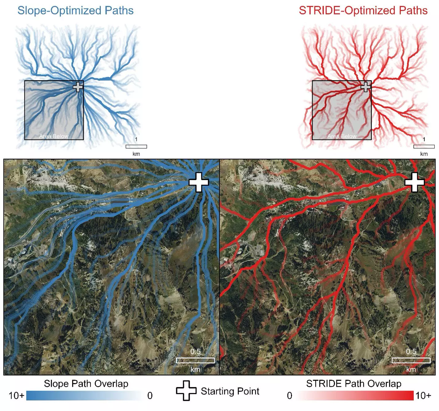
The true efficacy of STRIDE shines when compared with traditional slope-only models, which grossly underestimate traversal times. In simulations where emergency responders needed to reach injured hikers, the STRIDE model directed them along established trails and roads, naturally avoiding obstacles like dense forests. Contrarily, the slope-only model opted for routes through treacherous terrain, generating paths that could expose responders to greater danger. The implications of these findings underscore the importance of developing algorithms that align with intuitive human navigation.
Broader Applications and Future Implications
Notably, the versatility of the STRIDE model extends beyond wildland firefighting; it holds potential for applications in areas such as search and rescue operations, outdoor recreation planning, and even archaeological endeavors. The model can assist planners and professionals in a range of fields to develop strategies rooted in efficient and safe movement through varied landscapes. By improving the accuracy of travel time predictions, STRIDE enhances the survival odds of individuals in emergencies, cementing its relevance across disciplines.
Reflecting on the recent history of firefighting, it’s evident that the stakes are high. Incidents like the 2013 Yarnell Hill fire, which claimed the lives of several firefighters, illustrate the critical nature of preparation and knowledge. STRIDE, being publicly accessible, empowers individuals and organizations alike to enhance their safety protocols. Campbell emphasized the collaborative support received from the U.S. Forest Service, underscoring a shared vision of improving firefighter mobility and thereby, safety.
As wildfires become more prevalent, the demand for advanced navigational models like STRIDE will continue to grow. In providing a sophisticated and accurate tool for evaluating terrain-associated travel times, STRIDE marks a significant development in emergency response strategies. Ultimately, the results of this research could lead to safer evacuations and a deeper understanding of mobility dynamics, benefitting a diverse array of fields while emphasizing the need for ongoing innovation in disaster response methodologies.