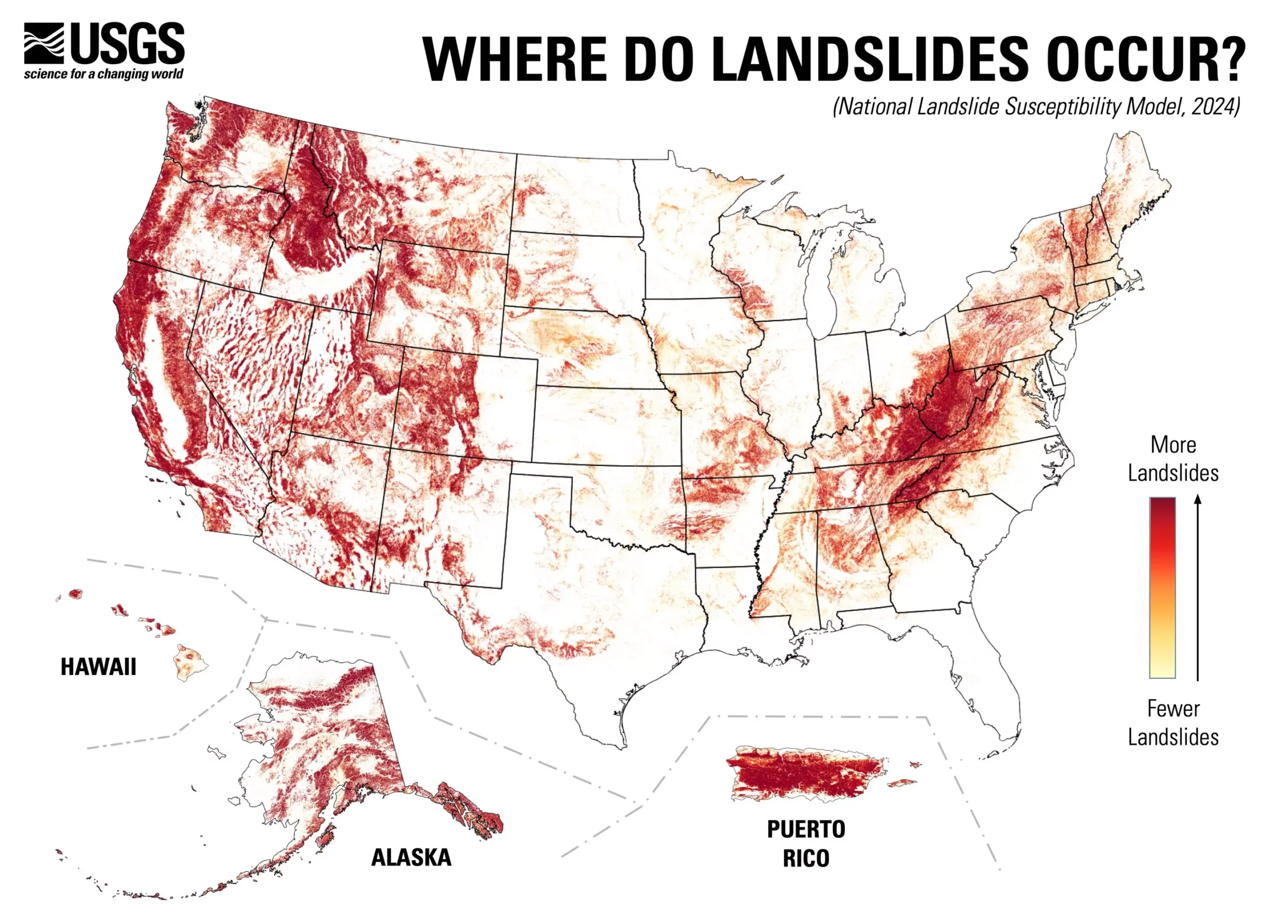
In a significant advancement for geological hazard assessment, the U.S. Geological Survey (USGS) has unveiled a comprehensive nationwide landslide susceptibility map that reveals a startling truth: nearly 44% of the United States is at risk for landslide events. This alarming statistic underscores the necessity for heightened awareness and preparedness regarding geological hazards that can disrupt lives and damage property. By creating a county-by-county breakdown, the map not only pinpoints areas at high risk, but also highlights regions that are relatively safe, a crucial distinction for effective land-use planning and risk management strategies.
The detailed maps produced by USGS represent a leap forward in our understanding of landslide susceptibility across the country. Previously, significant efforts had been limited to specific regions considered high-risk, leaving many areas inadequately evaluated. Now, with the aid of a comprehensive inventory of nearly one million past landslides, combined with high-resolution elevation data, researchers have been able to develop a much more nuanced understanding of geologic instability. This thereby aids planners and engineers in making informed decisions about infrastructure projects or land development, enabling more robust mitigation tactics against future landslides.
The methodologies used in creating the new landslide susceptibility map are noteworthy. Utilizing the cutting-edge capabilities of the USGS 3D Elevation Program, the researchers have been able to generate detailed topographical data that significantly outstrips previous continental and global maps. The application of advanced computing technology allows for more precise modeling of areas susceptible to landslide activity, thus improving the accuracy of hazard assessments. As such, this map serves not only as a current hazard indicator but as a tool for future research and mapping endeavors.
The map has profound implications for land-use planning and disaster preparedness. Municipalities and government bodies can now strategically focus their attention and resources on areas deemed most vulnerable to landslide activity. Ingenious usage of this map can inform zoning decisions, emergency management protocols, and long-term community safety planning. By proactively addressing areas identified as at risk, communities can work to minimize damage and protect lives, leading to a more resilient society.
With the landslide susceptibility map now readily available to the public, the responsibility shifts onto communities, policymakers, and individuals to harness this valuable resource. Public engagement and education regarding the map’s insights will be paramount—encouraging proactive measures and fostering a culture of preparedness. As Ben Mirus, a USGS research geologist, aptly stated, this national map aims to enhance our readiness for geological hazards. By integrating this information into planning and daily conversations, we can collectively move towards becoming a more hazard-ready nation, aware of the earth beneath our feet and the risks it may pose.