The increasing levels of nitrogen dioxide (NO2) in our atmosphere represent a burgeoning crisis, with far-reaching consequences for both public health and the environment. As a significant contributor to smog, nitrogen dioxide is not only a marker of urban pollution but also an indicator of the ongoing effects of fossil fuel combustion, particularly from vehicles and industrial plants. The detrimental impacts of this pollutant on respiratory health and overall air quality cannot be overstated; it fosters an environment conducive to respiratory problems and diminishes the quality of life in affected areas.
Recognizing the socio-environmental ramifications of nitrogen dioxide, researchers have long sought better methodologies to monitor its concentration and source. The introduction of advanced satellite technology has provided new insights into this atmospheric threat, marking a substantial shift in our ability to tackle air pollution.
Historically, satellite imaging has played a pivotal role in observing atmospheric conditions. However, previous technologies, including the widely used Sentinel-5P satellite, often couldn’t resolve pollution sources at an individual level. Instead, they aggregated data across broader areas, obscuring specific emission sources and limiting understanding of localized pollution dynamics.
In an exciting development, a recent study published in the Proceedings of the National Academy of Sciences has demonstrated that the Copernicus Sentinel-2 satellite, along with Landsat satellites, can detect nitrogen dioxide plumes from individual power plants with unprecedented precision. This capability signifies not just an incremental advancement, but a transformative leap in air quality monitoring. Researchers have shifted the narrative from generalized pollutant tracking to targeted analysis capable of identifying specific emitters, thereby holding industries accountable and fostering more effective regulatory practices.
Technical Mastery: How Satellites Detect Nitrogen Dioxide
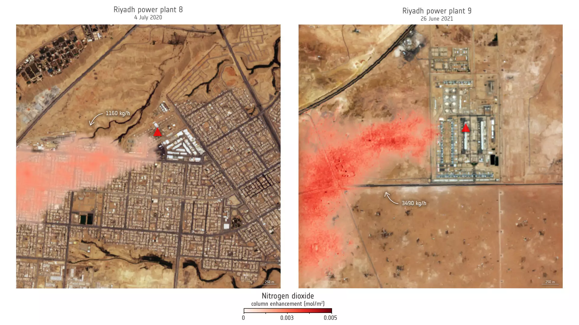
The secret behind the success of Sentinel-2 lies in its high-resolution imaging, initially designed for monitoring land use, vegetation, and water bodies. Unlike its predecessors, Sentinel-2 captures images that allow researchers to distinguish cropland from industrial complexes, thanks to its fine spatial resolution. Leveraging its blue and ultra-blue spectral bands, researchers have successfully identified nitrogen dioxide plumes rising from power plants, notably in regions such as Saudi Arabia and Wyoming, USA.
The ingenuity here stems from the application of previously existing technology to a new problem. With empirical evidence suggesting significant seasonal fluctuations in emissions, especially around peak air conditioning usage during summer months, the findings from these satellite observations broaden our understanding of pollution patterns. Lead researcher Daniel Varon’s comments highlight the importance of this resolution in urban contexts, signaling a shift toward precision in air quality management.
Confronting Challenges: The Limitations and Future Prospects
While the advancements in satellite technology present numerous opportunities, they are not without challenges. According to Varon, the imaging capabilities of Sentinel-2 and similar satellites are optimal over bright and uniform surfaces but struggle when confronted with complex terrain or darker environments. Such constraints appear to diminish the efficacy of air quality assessments in diverse geographical locations.
Despite these drawbacks, the study illuminates a pathway forward. The integration of satellite data with traditional monitoring systems enhances the robustness of air quality solutions. For areas lacking traditional monitoring infrastructures—often lower-income regions plagued by pollution—these satellite capabilities represent a potential lifeline for environmental oversight.
The imminent launch of Sentinel-2C in September 2024 promises to extend the capabilities of its predecessors, enabling more granular analysis across an even wider swath of land. With its capacity to generate data across 13 spectral bands, we may soon see a deeper understanding of atmospheric conditions and emission trends, equipping researchers and policymakers with the information necessary to devise effective air quality improvement strategies.
The implications of this research extend beyond mere scientific interest; they resonate deeply within discussions of public health and environmental policy. As cities grapple with rising air pollution levels and their associated health burdens, the ability to pinpoint emission sources becomes crucial for effective regulation and enforcement.
The study’s findings equip policymakers with tools to identify pollution culprits, facilitating accountability in sectors responsible for nitrogen dioxide emissions. This newfound knowledge allows for targeted interventions, potentially leading to improved air quality and reduced health risks for urban populations. By incorporating satellite data into existing regulatory frameworks, stakeholders can prioritize resource allocation to effectively combat air pollution.
Recognizing the potential of such innovative monitoring techniques, the future of air quality management seems replete with possibilities. The integration of satellite technology into public policy can serve as a beacon for efforts aimed at fostering healthier communities and sustainable ecosystems, ultimately leading to a cleaner and healthier world.