The advent of unmanned aerial vehicles (UAVs), popularly known as drones, has revolutionized various fields including surveillance, mapping, and data collection. These versatile flying machines are equipped with advanced technology that allows them to explore and monitor environments with remarkable efficiency. With ongoing advancements in UAV technology, researchers are investigating innovative methods to leverage drones for creating detailed maps and three-dimensional (3D) visualizations of the physical world. A particularly noteworthy breakthrough is represented by a new system called SOAR, developed by researchers from Sun Yat-Sen University and the Hong Kong University of Science and Technology.
SOAR stands out as a comprehensive solution to the challenges associated with 3D environment reconstruction. By enabling a team of UAVs to explore and analyze their surroundings simultaneously, this innovative system is poised to set new standards in the UAV industry. The fundamental aspects of SOAR were outlined in a recent paper scheduled to be discussed at the IEEE/RSJ International Conference on Intelligent Robots and Systems (IROS) 2024. The team aims to address the limitations inherent in traditional UAV methodologies, which often fall into either model-based approaches or model-free strategies but seldom optimize the strengths of both.
In the current landscape of UAV systems, many methods for 3D reconstruction are either too slow or rely heavily on pre-existing models, making them costly and inefficient. Mingjie Zhang, one of the co-authors of the SOAR project, highlighted this concern, stating that the existing methodologies were often inefficient, especially when confronted with dynamic environments. To create a robust solution, the research team sought to develop a multi-UAV system that could navigate and reconstruct environments autonomously while collecting data in real time. Essentially, the goal was to streamline the data collection process to facilitate a more effective reconstruction experience.
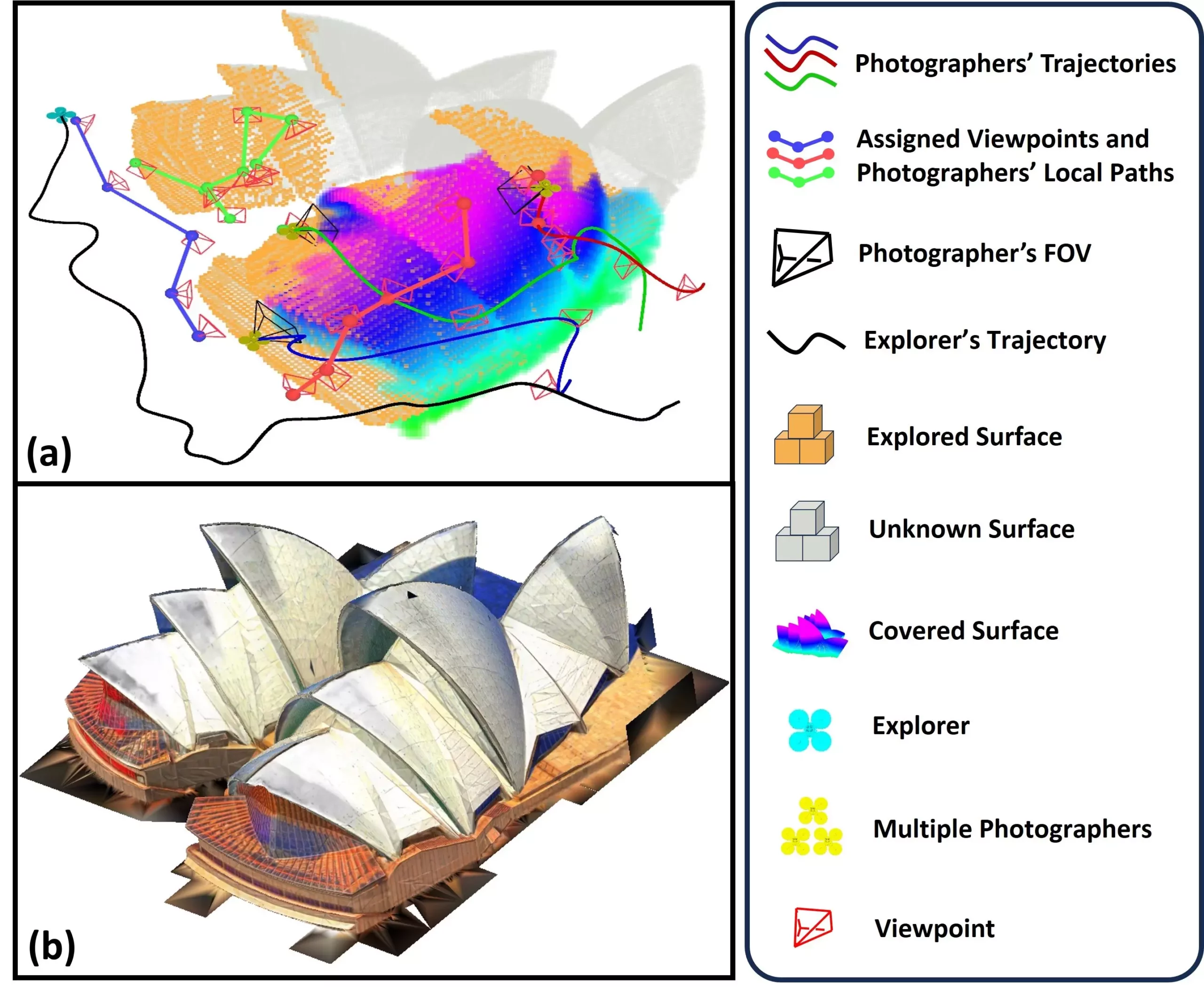
At the heart of SOAR is its unique architecture, which consists of an explorer UAV and multiple photographer UAVs. The explorer UAV is equipped with LiDAR technology for quick mapping of surroundings, while the photographer UAVs are outfitted with high-resolution cameras for detailed image capture. The process begins when the explorer UAV maps the environment using a surface frontier-based strategy, gradually generating viewpoints for the photographers to capture.
This method of incremental viewpoint generation allows the UAVs to adapt to fresh data systematically, ensuring that the environmental complexities are thoroughly captured. By clustering viewpoints and employing a task assignment strategy referred to as Consistent-MDMTSP, SOAR optimizes the workload across UAVs. This careful coordination ensures that each photographer is assigned efficiently, minimizing unnecessary detours and enhancing overall operational speed.
The development team conducted extensive simulations to test the efficacy of the SOAR system. Their findings revealed that SOAR outperformed existing state-of-the-art methods for 3D reconstruction tasks, proving that it is not only effective but also scalable. The algorithms central to SOAR employ an incremental design, balancing real-time planning with overall efficiency – a critical requirement for tasks that necessitate prompt responses.
Zhang praised the framework’s ability to address various practical issues, stating, “A key achievement of our study is the introduction of a novel framework for fast autonomous aerial reconstruction.” This adaptability positions SOAR as an agile tool that can respond to changing environmental conditions.
Looking ahead, the implications of SOAR are vast. From urban planning to restoration projects for historical sites, the application of this UAV system could revolutionize how we visualize and reconstruct different environments. For example, in disaster scenarios, SOAR could expedite damage assessments, providing vital information for rescue operations. The potential use cases extend into constructing detailed 3D models for video games, where realism and accuracy are key for immersive user experiences.
Moreover, the research team recognizes the need for continual refinement. Future iterations of the SOAR system aim to enhance task allocation strategies and incorporate real-time feedback into their processes. Exploring the development of predictive capabilities could significantly cut down the time needed for effective 3D reconstruction, thereby impacting multiple industries positively.
The SOAR system represents a significant leap forward in the realm of UAV technology and environmental reconstruction. By combining advanced data collection methods and efficient task management strategies, this innovative approach promises to redefine how we interact with and visualize our surroundings. As further research unfolds, the impact of SOAR could extend beyond academic applications, ultimately benefiting societal needs in urban planning, disaster relief, and even entertainment sectors. The future is bright for autonomous aerial technologies, and SOAR is at the forefront of this exciting evolution.